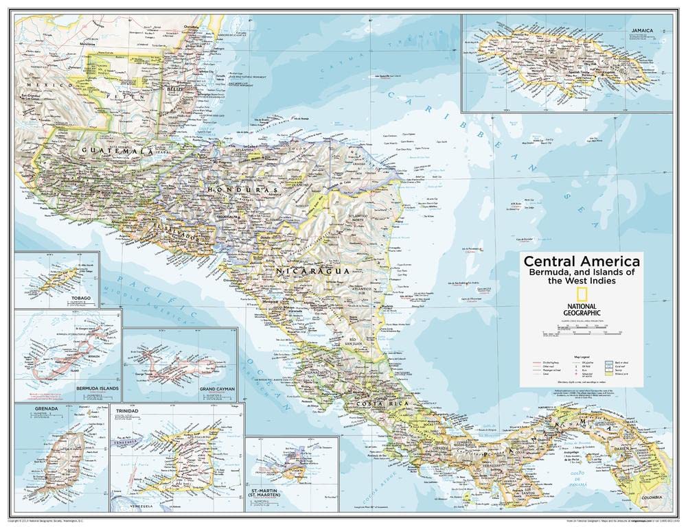
National Geographic Maps: Central America, Bermuda, and Islands of the West Indies Wall Map - Compact - 21 x 16 inches - Front Lamination
$25.99
| Brand | National Geographic |
| Merchant | Amazon |
| Category | Office Supplies |
| Availability | In Stock Scarce |
| SKU | B0C63XV482 |
| Color | Blue, Green |
| Size | Front Lamination |
| Age Group | ADULT |
| Condition | NEW |
| Gender | UNISEX |
About this item
National Geographic Maps: Central America, Bermuda, and Islands of the West Indies Wall Map - Compact - 21 x 16 inches - Front Lamination
COMPACT WALL MAP: This wall map measures 21 x 16 inches, which is a perfect size for a wall poster collection HIGH QUALITY PRINT: Your laminated map has a glossy finish so that you can use dry erase markers on the map to highlight features, make plans, and share unique information with others. Lamination is also extremely durable, resistant to folding or ripping ROLLED IN A STURDY TUBE: Your map is rolled and packaged in a sturdy tube to protect it during shipment A MUST-HAVE FOR COLLECTORS: Be the first to own this map individually, previously only available as part of the 10th Edition of the National Geographic Atlas! ICONIC CARTOGRAPHY: National Geographic's maps are the standard others are measured against. You can count on this product having the highest quality content and display in the industry. This Central America, Bermuda, and Islands of the West Indies map of physical and political features can fit in any space. Showcasing the countries in stunning detail with state-of-the-art cartographic techniques delivering accuracy and exceptional quality, the innovative and engaging design makes the content easily accessible and user-friendly.
Ideal for classrooms with an emphasis on teaching geography or environmental themes. The inclusion of physical features gives your students a genuine feel for how our world appears.
This map uses a bright, easy to read color palette featuring blue oceans and stunning shaded relief that has been featured on National Geographic wall maps for over 75 years. Drawn in the Azimuthal Equidistant projection, this map ensures that all points on the map are at proportionally correct distances from the center point. Insets of Belize, Bermuda Is. (U.K.), Costa Rica, El Salvador, Grand Cayman (U.K.), Grenada, Guatemala, Honduras, Jamaica, Nicaragua, Panama, St.-Martin (Fr.), St. Maarten (Neth.),Trinidad and Tobago add detail to this classic map.
This map is found in National Geographic's 10th Edition World Atlas and is now available as a stand alone product.
Your laminated map has a glossy finish so that you can use dry erase markers on the map to highlight features, make plans, and share unique information with others. Lamination is also extremely durable, resistant to folding or ripping. Your map is rolled and packaged in a sturdy tube to protect it during shipment.
| Brand | National Geographic |
| Merchant | Amazon |
| Category | Office Supplies |
| Availability | In Stock Scarce |
| SKU | B0C63XV482 |
| Color | Blue, Green |
| Size | Front Lamination |
| Age Group | ADULT |
| Condition | NEW |
| Gender | UNISEX |
Similar Products


Compare with similar items

Coach Thank You Cards Coach Gifts for Me... |

Signs ByLITA Classic Framed Please Do No... |

CJiangpo 30Pcs Coquette Pink Bow Sticky ... |

4Pcs Red Rhinestone Bling Metal Ballpoin... |
|
|---|---|---|---|---|
| Price | $7.99 | $8.99 | $9.99 | $11.99 |
| Brand | ACCOLIAMBER | Signs ByLITA | CJiangpo | Jinshining |
| Merchant | Amazon | Amazon | Amazon | Amazon |
| Availability | In Stock | In Stock | In Stock | In Stock |