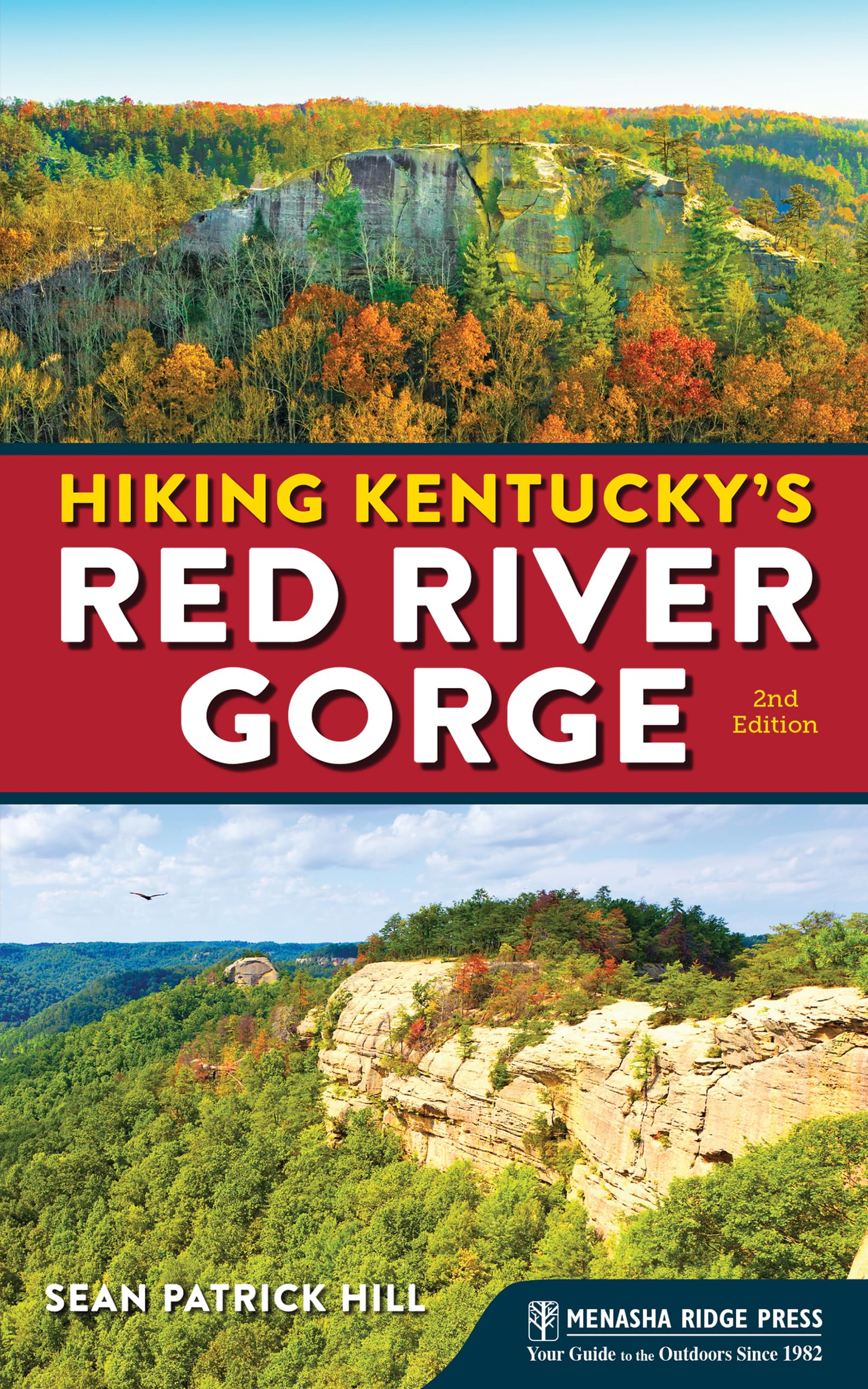
Hiking Kentucky's Red River Gorge
$13.49
| Brand | Sean Patrick Hill |
| Merchant | Amazon |
| Category | Books |
| Availability | In Stock |
| SKU | 1634041372 |
| Age Group | ADULT |
| Condition | NEW |
| Gender | UNISEX |
| Google Product Category | Media > Books |
| Product Type | Books > Subjects > History > Americas > United States > State & Local |
About this item
Hiking Kentucky's Red River Gorge
Hike and Backpack in Nature’s Stunning Beauty With the most rock arches east of the Mississippi, the Red River Gorge stands alone for scenery. Get the definitive guide to this famous region―including the Red River Gorge Geological Area, Natural Bridge State Resort Park, and Clifty Wilderness. This updated, full-color edition showcases 28 of the best hikes in the area, from the kid-friendly Original Trail to the challenging Rough Trail. With the expert guidance of Sean Patrick Hill, you’ll discover the Gorge’s hidden treasures: lush forests, secluded waterfalls, brilliant wildflowers, natural arches, and more. The book includes 28 routes that lead readers along carefully maintained trails - GPS-based trail maps and elevation profiles - Detailed directions to trailheads - Ratings for key elements to help readers decide which hikes to choose - Route details and full-color photography - Recommendations for combining routes into longer adventures Whether you’re hitting the Gorge for a short hike or a full weekend, Hiking Kentucky’s Red River Gorge is your guide to experiencing the famed natural wonder on foot. Sean Patrick Hill lives in Louisville, Kentucky, where he spends time with his daughter, practices photography, and writes. As a hiker and backpacker, he has walked trails across the country, from the Pacific Crest Trail to the Appalachian Trail, including rambles in the Grand Canyon, the Delaware Water Gap, Yosemite National Park, the Rocky Mountains, the Olympic Peninsula, and the Oregon Cascades. In Kentucky, he tends to stick to the Bernheim Arboretum and Research Forest (where he volunteers as a trail ranger) and the Jefferson Memorial Forest, though he will on occasion ramble as far as Pine Mountain, the Cumberland Gap, and, of course, the Red River Gorge. Pilot Knob State Nature Preserve Scenery: 3 - Trail Condition: 3 - Children: 3 - Difficulty: 3 - Solitude: 4 - GPS Trailhead Coordinates: Pilot Knob Trailhead N 37˚ 54.723' W 83˚ 56.697' - Distance & Configuration: 4.5-mile loop - Highlights: Wooded terrain and a view over the Cumberland Plateau - Hiking Time: 3 hours - Elevation: 800' at the trailhead, ascending to 1,420' - Access: Open 24/7; vehicle pass required for overnight parking - Maps: USGS Levee ; trail map available online at eec.ky.gov/Nature-Preserves/Brochures/PilotKnobBrochure_color.pdf - Facilities: None - Wheelchair Access: None - Comments: Dangerous cliffs are present and should be avoided, especially by children. - Contacts: Kentucky State Nature Preserves Commission: 502-782-7839, eec.ky.gov/Nature-Preserves/Locations/Pages/Pilot-Knob.aspx Overview Just off the Bert T. Combs Mountain Parkway, west of Red River Gorge, lies the 742-acre Pilot Knob State Nature Preserve. Pieced together beginning with an original purchase made with The Nature Conservancy, the preserve covers creek bottoms, wooded ridges, and the highlight, a 730-foot-high sandstone outcrop that is said to have been visited by Daniel Boone and overlooks both the Bluegrass region and the beginning of the Cumberland Plateau. Though you can take a fairly steep incline straight to the top, it’s worth it to tour the entire area, rich in wildflowers and native Kentucky hardwoods. Route Details From the parking lot, set out east on the trail, crossing Brush Creek. In 0.2 mile you’ll reach the first junction; to the right is the 0.4-mile loop of the Millstone Quarry Trail, which is worth an exploration. To the left is the Oscar Geralds, Jr. Trail, which charges upward in just under a mile to the peak of Pilot Knob; to do so, simply continue upward, staying left at both junctions with the Sage Point Trail. While this is a decent hike, though short, it’s more challenging―and ultimately more fulfilling―to do the entire loop of the area. For the full loop, go right at the first junction with the Sage Point Trail. From here, you’ll amble along ridgelines thick with oaks and hickories, dropping to another creek and wildflower-filled bottomland (sometimes crossing power line roads) and climbing again toward the prominence of Pilot Knob. After completing the 2-mile Sage Point Trail, watch for a trail to the right and follow it 0.4 mile to some stunning rock formations and, finally, the cliff-edge view that, in spring, flowers with mountain azalea. To return, follow this trail back 0.4 mile, then turn right on the Oscar Geralds, Jr. Trail and follow it for 0.3 mile. As you descend, look up and to the right to see the cliff you were just on. Keep right at the junction with the Sage Point Trail, and again keep right after another 0.3 mile at the junction with the Millstone Quarry Trail. Return the last 0.25 mile to your car. Directions From Exit 16 off Bert T. Combs Mountain Parkway, go right (north) on KY 15 for 2.9 miles. Turn right on Brush Creek Road and follow it 1.6 miles to the parking lot at the end of the road. The trail begins at the edge of the lot.
| Brand | Sean Patrick Hill |
| Merchant | Amazon |
| Category | Books |
| Availability | In Stock |
| SKU | 1634041372 |
| Age Group | ADULT |
| Condition | NEW |
| Gender | UNISEX |
| Google Product Category | Media > Books |
| Product Type | Books > Subjects > History > Americas > United States > State & Local |
Similar Products


Compare with similar items

Wicca Book of Spells: The Ultimate Book ... |

Composition Notebook: Vintage Matte Cove... |
Except Ye Repent: Ye Shall All Likewise ... |

A Slovak Odyssey of a Mother Love, Loss,... |
|
|---|---|---|---|---|
| Price | $15.99 | $8.14 | $16.99 | $34.95 |
| Brand | Athena Crowley | FLOURISH Learning | Harry A Ironside | John Michael Kudlas |
| Merchant | Amazon | Amazon | Amazon | Amazon |
| Availability | In Stock | In Stock | In Stock | In Stock |