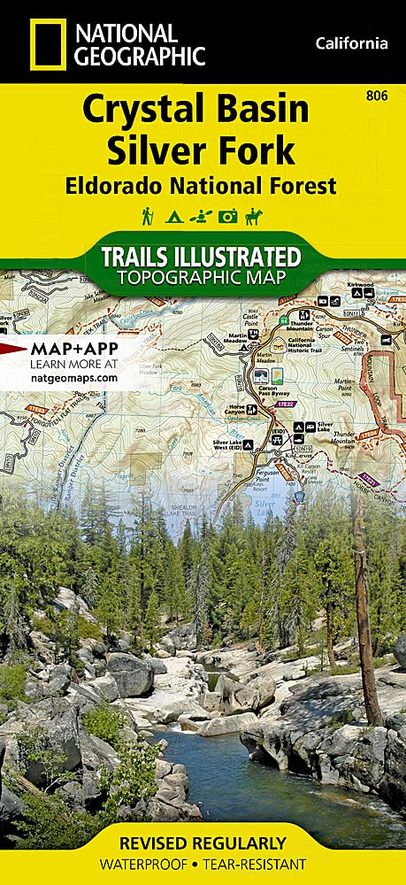
Crystal Basin, Silver Fork Map [Eldorado National Forest] (National Geographic Trails Illustrated Map, 806)
$14.95
| Brand | National Geographic Maps |
| Merchant | Amazon |
| Category | Books |
| Availability | In Stock |
| SKU | 1566952646 |
| Color | No Results |
| Age Group | ADULT |
| Condition | NEW |
| Gender | UNISEX |
| Material | Crystal |
| Google Product Category | Media > Books |
| Product Type | Books > Subjects > Travel > United States > West > Pacific |
About this item
Crystal Basin, Silver Fork Map [Eldorado National Forest] (National Geographic Trails Illustrated Map, 806)
• Waterproof • Tear-Resistant • Topographic Map National Geographic's Trails Illustrated map of Crystal Basin and Silver Fork covers the Eldorado National Forest, from its northern boundary with Tahoe National Forest to its southern boundary with Stanislaus National Forest. The map provides both unmatched detail and valuable information for outdoor enthusiasts exploring this part of California's Sierra Nevada. Expertly researched and created in partnership with the U.S. Forest Service and others, this map features key points of interest including Mokelumne and Desolation Wildernesses, Hell Hole and Union Valley Reservoirs, Silver Lake and Kirkwood Ski Area. An informative summary of each wilderness area, safety tips, including a special section on bear safety tips, recreation tips and agency contact information are included as well. The area's many trails are clearly marked and color coded according to their designated usage, whether you're exploring on foot, horseback, bike, or motorized vehicle. Trail mileage between intersections along with contour lines and elevations will help you choose the path that's right for you. The Pony Express National Historic Trail that bisects the area is highlighted along with the California National Historic Trail, Pacific Crest Trail and Rubicon OHV Trail. Carson Pass Scenic Byways is noted for those wishing to take in the scenery by car. The area is full of water and land recreation areas all of which are highlighted on the map. Some of the many recreation features include: snowmobile trails, ski areas, sno-parks, fishing and boat access, campgrounds and RV camping, scenic viewpoints and wildlife viewing areas. Every Trails Illustrated map is printed on "Backcountry Tough" waterproof, tear-resistant paper. A full UTM grid is printed on the map to aid with GPS navigation. Other features found on this map include: Desolation Wilderness, Eldorado National Forest, Mokelumne Wilderness, Mosquito Ridge, Stanislaus National Forest, Tahoe National Forest, Union Valley Reservoir. Map Scale = 1:63,360 - Sheet Size = 37.75" x 25.5" - Folded Size = 4.25" x 9.25" Founded in 1915 as the Cartographic Group, the first division of National Geographic, National Geographic Maps has been responsible for illustrating the world around us through the art and science of mapmaking.Today, National Geographic Maps continues this mission by creating the world's best wall maps, recreation maps, atlases, and globes which inspire people to care about and explore their world. CRYSTAL BASIN/SILVER FORK #806
| Brand | National Geographic Maps |
| Merchant | Amazon |
| Category | Books |
| Availability | In Stock |
| SKU | 1566952646 |
| Color | No Results |
| Age Group | ADULT |
| Condition | NEW |
| Gender | UNISEX |
| Material | Crystal |
| Google Product Category | Media > Books |
| Product Type | Books > Subjects > Travel > United States > West > Pacific |
Similar Products


Compare with similar items

Soccer Team Upset (Fred Bowen Sports Sto... |

Letters from the Desert: The Full Text... |

Kalimba Songbook, Christmas Songs: Big M... |

By B.B. Hiller - Rent A Third Grader (Li... |
|
|---|---|---|---|---|
| Price | $6.99 | $29.95 | $12.97 | $15.00 |
| Brand | Fred Bowen | Saint Barsanuphius | Peter Music Publishing | Bonnie Bryant Hiller |
| Merchant | Amazon | Amazon | Amazon | Amazon |
| Availability | In Stock Scarce | In Stock | In Stock | In Stock Scarce |